Northwest Lancaster Rail Trail
A Very Easy 27 mile shared use path 70 minutes away
Note that Pennsylvania has prioritized connecting the Northwest Lancaster Rail Trail, Enola Low Grade Trail, the Chester Valley Trail, and the Schuylkill River Trail to create the Schuylkill to Susquehanna Greenway. While the the Chester Valley Trail and the Schuylkill River Trail were connected in 2023, work to close the remaining gaps will take many years.

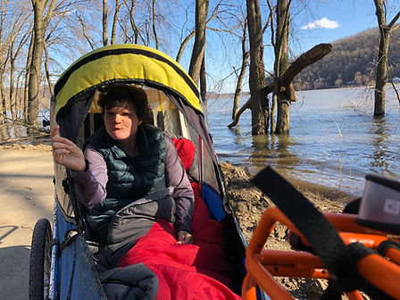
Margot getting muddy by a flooding Susquehanna - March 2021
Universal Access (UA): The overall path does not meet standards for Shared Use Paths with respect to running grade with an Overall Grade Rating of Very Easy. As a shared use path, it otherwise meets all standards for surface, obstacles, cross-slope, and passing spaces.
Effort: This 26.7 mile out and back shared use path (13.4 miles each way) has a Flat Equivalent Length of 27.6 miles and merits a Cumulative Grade Rating of Very Easy. Depending on the direction, the longest continuous grades are as follows: a 120-220' section with at least easy grades, a 20-80' section with at least easy to moderate grades, and a 10-20' section with at least moderate grades.
Stress: As a shared use path, this is generally rated as very low stress for most users. There are short sections on quiet streets in Marietta.
Other features: This is a busy trail, running close to the Susquehanna River along its entire length, with some beautiful views of the river (the picture to the left was taken during a spring flood). Most of the route is shaded, with the woods especially heavy at the southern portion near Chickie's Rock. There are plenty of parks (with restrooms or porta-pottis), and benches and picnic areas on the way. There are also interesting pubs in the sidestreets of Marietta, and more if you take the detour into the downtown (see below).
Connections: The marked route takes you briefly through side streets on the edge of Marietta, but you can also take a longer detour through the town along Market Street, connecting back with the trail using Bridge and New Haven Streets (though this requires sharing the road on the quiet main street). Click here for a Google map link). The state has prioritized connecting the Northwest Lancaster Rail Trail, Enola Low Grade Trail, the Chester Valley Trail, and the Schuylkill River Trail to create the Schuylkill to Susquehanna Greenway. While the the Chester Valley Trail and the Schuylkill River Trail were connected in 2023, work to close the remaining gaps will take many years.
Getting there: Click here (or on the map) for directions to the trailhead at the Columbia River Crossing (the closest to Kennett Square).
Trail maps: To see the grade in each direction for each 10' section on the map below, click on Filter and select the direction (remember to toggle the filter on).
-
Click on Legend to see the symbols indicating different grades.
-
Click Home to re-center the map on the trail.
-
Click here to open the map in a new window.
-
Click Your Location to track your progress while you hike.
Home
Your location
Legend
Filter
Layer


