Brinton Run Preserve
Flat to Hard Meadow Trails 15 minutes away

Howe Trail
A .7 mile Low Stress walking trail with Hard grades

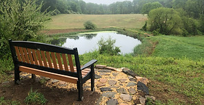
This is a mowed, open meadow trail heading east and gently downhill from the parking area to approach the pond pictured above (which is technically in an area closed to the public).
Universal Access (UA): The entire loop exceeds UA Standards with respect to Running Grades and Cross-Grades. One .25 mile section to the westernmost point overlooking the pond (.5 miles round trip) heading clockwise from the parking lot would meet UA standards except for a 250' section of 5-8.33% grades.
Effort: This .7 mile walking trail has a Flat Equivalent Length of .8 miles. Maximum Grades are rated as Hard. because of a 70' section of 12.5-20% grades. Depending on the direction, the longest continuous grades are as follows: a 40-90' section with at least easy grades, a 10-90' section with at least easy to moderate grades, a 10-70' section with at least moderate grades, and a 10' section with difficult grades. Longer and more steep uphill sections are found going clockwise. Click the map below for more detailed information.
Stress: This is rated overall as Low Stress. Greatest stressors include a section on the northern half with 5-10% cross-grades (which could be partially avoided by walking on the road). As a mowed meadow trail with no obvious drainage problems, this provides a wide, firm, and relatively even walking surface.
Other features: This is a quiet trail. There is a bench near the parking lot and another in the area marked on the map as currently closed to the public.
Connections: You can continue on to the Greene Trail to add about .5 miles to your total walk
Trail maps: Click directly on the maps below to navigate, or open the map in a new window for the trail running clockwise or counter-clockwise.
-
Click Home to re-center the map on the trail.
-
Click Your Location to track your progress while you hike.
-
Click on Legend to see the symbols indicating different grades and cumulative grade ratings
-
Click on Layer to select specific layers (like 10' grade ratings, cumulative grade ratings, and so on) you want to turn off.
Home
Your location
Legend
Filter
Layer

Greene Trail
An Easy / Universal Access walking trail .7 miles long
This is a mowed, open meadow trail heading north and then east from the parking area .
Universal Access: This trail appears to comply with all Universal Access standards. The wood mulch parking lot probably does not meet standards for firmness.
Effort: This walking trail loop is .64 miles long, has a Flat Equivalent Length of .68 miles and merits an Overall Grade Rating of Universal Access. Depending on the direction, the longest continuous grades are as follows: a 10-20' section with at least easy grades, and a 10' section with at least easy to moderate grades. Click the map below for more detailed information.
Stress: As a mowed meadow trail with no obvious drainage problems, this provides a wide, firm, and relatively even walking surface.
Other features: This is a quiet trail. There is a bench near the parking lot.
Connections: You can continue on to the Howe Trail to add about .5 miles to your total walk
Trail maps: Click here to open the map in a new window. To see the grade in each direction for each 10' section on the map below
-
Click Home to re-center the map on the trail.
-
Click Your Location to track your progress while you hike.
-
Click on Legend to see the symbols indicating different grades and cumulative grade ratings
-
Click on Filter and select the direction (remember to toggle the filter on).
-
Click on Layer to see the different 10' grade ratings and cumulative grade ratings
Home
Your location
Legend
Filter
Layer


